Voice of Gowanus Pleads With Officials for Attention to the Neighborhood’s Toxic Sites

Picture Obtained from Star-Revue at: (https://www.star-revue.com/environmental-protection-agency-epa-will-begin-dredging-the-gowanus-canal/)

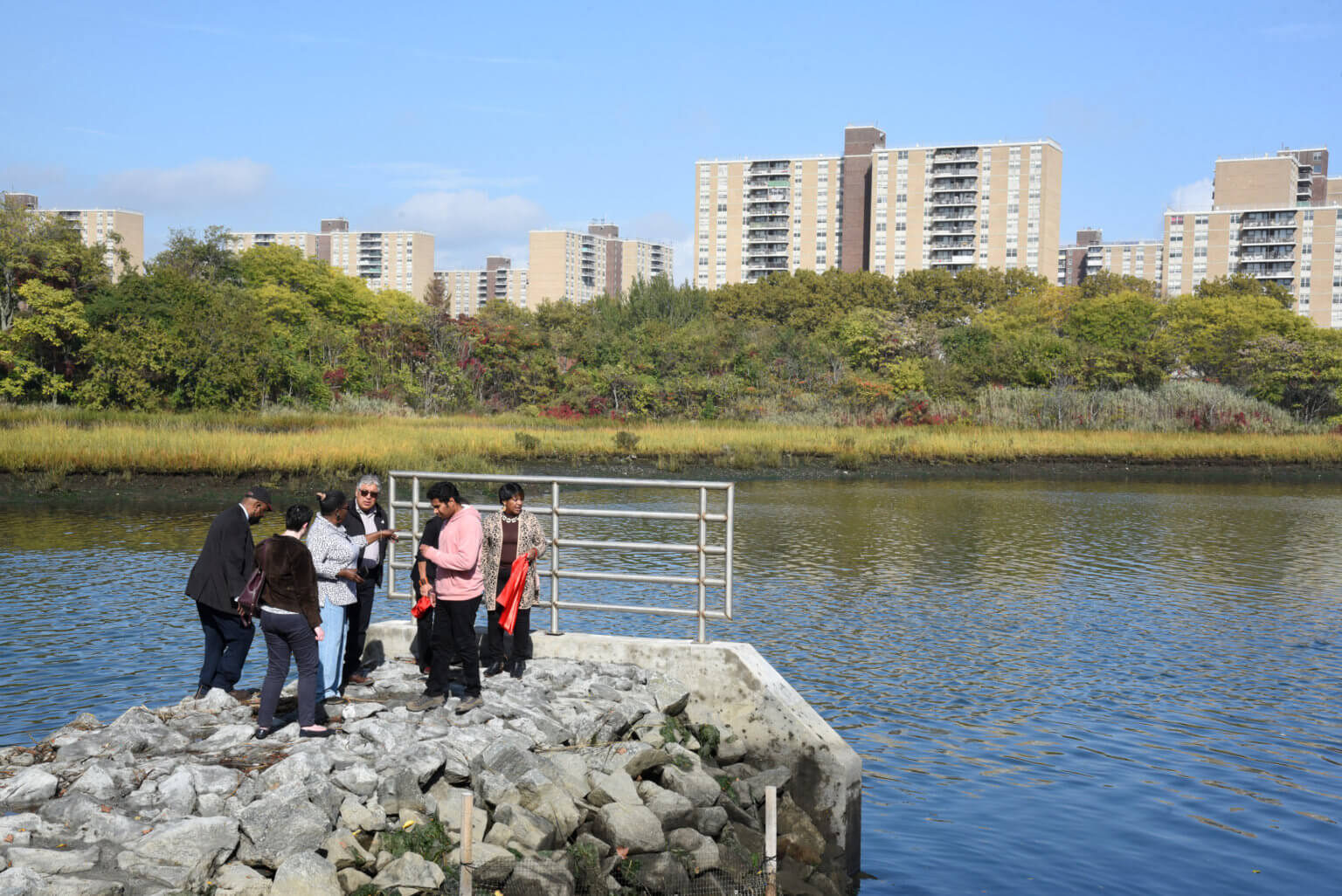
The community has long ago spoken about the dangers of redevelopment in Gowanus’ contaminated coasts.

The Gowanus Canal is located in a once industrial area of new York city Brooklyn, where factories dumbed manufacturing byproducts into the water.

The canal was designated a superfund site (around 2013?) which means the EPA would be cleaning out the canal for years to come (estimated completion is 2019 according to federal EPA representative Christos Tsiamis). While there are doubts around whether the canal will ever be safe to use for fishing for example, the goal by the Superfund is to return the site to a productive use.

As the cleanup progresses, the filth, heavy metals and sewage that has settled on the bottom is brought up to the surface. What has been called 10 feet of “black mayonnaise” is being dredged from the bottom of the canal- largely consisting of coal tar that has also sunken into the ground near the coastlines. Plumes of rainbow from oil on the surface, and a strong smell of garbage and sewage can be smelled when the cleanup is in progress.

As the cleanup process has been ongoing, billionares have been buying up land with the anticipation of developing 82 blocks of 3000 affordable housing units around the canal.

A rezoning lawsuit by Voice of Gowanus, Friends and Residents of Greater Gowanus, and individuals in the community, filed stating that the city violated environmental laws when it had approved the rezoning from manufacturing to mixed use 3 months back. They argue the development is unsafe for the residents who will live in the developments to come.

On March 15th, 2023 the EPA announced the started building of the 12-million gallon sewage tanks that will serve to protect the community from further contamination and pollution during future storms. Still, as happy as the community is with the tanks finally starting construction, a news interview on Spectrum news with Martin Bisi, a Voice of Gonawus member states, “…it’s not enough to take care of the environmental problems in Gowanus, it does not address the profound contamination that we have in the sites around the canal” Those that agree state that there are at least 30 sites that will recontaminate the canal and endanger those living in the proposed future housing developments. The sewage tanks that are built are stated by the VoiceofGowanus organization website to be inadequate, them saying, “…the retention tanks are only meant to deal with the current number of residents in the community; they don’t take into account the additional sewage that will be produced by 20,000 planned future residents…Without the required retention tanks, and given increases in rainfall as a result of climate change, sewage will (and has) backed up into people’s homes”(voiceofgowanus.org).

The VoiceofGowanus blog page also links to a publication as recent as March 9th 2023, exposing that the NYS DEC discovered and failed to report residents of the cancer-causing toxic fumes rising into the building of the Royal Palms Shuffleboard Club, which were discovered a year prior. The fumes come from an industrial solvent, found at “10,000 times the allowable amount under New York State Department of Health guidelines” (Gothamist). This particular chemical’s vapors are linked to kidney and liver cancer. Concerningly, many around the venue having been exposed to it for years.

There has been no plan to remove all the underground toxins, as would have to be done to be in compliance with state standards. And as the ground water under the Royal Palms club flows towards the Canal, leaching of contaminated water into the canal would continue even after the Gowanus Canal is cleaned.

The Gothamist has quoted Dr. Ana Navas-Acien, professor of environmental health sciences saying, “If you have a very large population living in an area that is affected by this chronic exposure then you’re really putting a lot of people at risk.” We’ve reached out to her for further comments but heard no reply.

Looking to create and inform citizen activists, the VoiceofGowanus twitter is actively posting and campaigning people on their website to plea for governor Hochul to remediate the toxic sites around Gowanus canal to pre-disposal (of toxic chemicals) conditions, all to keep future generations in the coming inevitable developments safe.

Residents and Community Leaders Express Unsatisfaction with City’s Billion Dollar Efforts to Combat Flooding

people stand on sewer outfall at fresh creek

The newly- installed tide gate chambers along Fresh Creek Basin, on the eastern side of Canarsie, designed to help prevent flooding and overflowing of the sewage systems.

Photo by Caroline Ourso for The Brooklyn Paper

By Shania Permell- James

March 28, 2022

Ten years after Superstorm Sandy left her mark on New York City, residents of Canarsie, Brooklyn are still scrambling to prepare for the next major storm. A neighborhood that was once never accounted for in the city’s floodplain now finds themselves searching for protection against storm surges from Paerdegat Basin and Fresh Creek Basin. With proposed changes from the city and installed tide gate chambers from the state, Canarsie remains at risk of severe flooding in 30 years and residents have expressed that while these efforts provide decent improvement, they are not enough and leave them unprepared for future storm events.

Hurricane Sandy impacted over 2,800 properties in Canarsie, located in the southeastern portion of Brooklyn. Surrounded by 3 bodies of water; Paerdegat Basin on the west, Fresh Creek Basin on the east, and Jamaica Bay to the south it is incomprehensible that the city neglected to include the neighborhood within the floodplain leaving thousands of residents to fend for themselves as their homes and businesses experienced major flooding with catch basins at Fresh Creek Basin overflowing. Fast forward to today, a $14 million project led by Governor Hochul’s Office of Storm Recovery installed new tide gate chambers along the shoreline of Fresh Creek Basin, on the east side of Canarsie.

The efforts to aid the flooding risk began in 2017 when Canarsie was included in the Resilient Neighborhoods initiative by the New York City Department of City Planning. The 46-page plan, that can be found on the NYC Department of City Planning’s website, details “neighborhood specific strategies for the continued vitality and resiliency of ten neighborhoods in the city’s floodplain.” The three primary goals driving their work in Canarsie are listed as reducing the neighborhoods flood risk by promoting building retrofits and flexibility in zoning to accommodate retrofitted properties, planning for adaptation over time with climate change and the continued risk of sea level rise, as well as creating resilient and vibrant neighborhoods by increasing the capacity of local businesses in the neighborhood. ­­

One of the major recommendations mentioned in this initiative was for homeowners to retrofit their homes by raising it six- feet. When speaking to Harold Jones, Executive Director of the Canarsie Community Development Inc. (CCDI), he shared that due to the risk of flooding in the neighborhood all residents are required to retrofit their homes or run the risk of getting charged up to four times their current flood insurance rate, which after Hurricane Sandy all residents were required to have. “I’m not raising mine,” said Jones when asked how the news is being taken by most residents. He also spoke about the CCDI’s Homeowner Audit Project that provided technical assistance and financial tools to homeowners who wanted to retrofit their homes, which carried a price tag of $1.5 million from the NY Rising Community Reconstruction Plan’s Community Development Block Grant for Disaster Recovery.

As an engineer himself, Mr. Jones applauded the U.S. Army Corps of Engineers on their $52 billion proposal to build 12 moveable sea barriers across waterways around Brooklyn, Queens, Staten Island and New Jersey, but expressed his disappointment that the project will take 7 years to get started and another 14 years before it is completed, 21 years in total. With the neighborhood set to be severely impacted by flooding in 30 years, Jones is not satisfied by the proposal or current efforts that have been made thus far. Despite the little improvements that have been made within the neighborhood’s waterways and residencies, Canarsie is drastically unprepared for the next major storm that may strike New York City.

Jones shared that he had created an emergency plan for the neighborhood in the event of another major storm, but it is not taken seriously by both residents and politicians. “We are the only neighborhood in this city without a community center. The nearest emergency site is over 3 miles away in East New York,” Jones informed me as we spoke about the community involvement in the neighborhood.

Residents continue to express their dissatisfaction with the city’s efforts against flooding, and community leaders continue to propose new solutions that are likely to help, but just how much needs to be done to change the fate of this neighborhood nestled in between two basins right on Jamaica Bay? This is a question that Harold Jones and other community leaders are constantly searching to answer. There is hope that the current efforts taken may protect Canarsie from minor storm surges, but the fate of the neighborhood against another major storm event remains in the air.

A Socioeconomic Perspective on Flooding in Hamilton Beach and Broad Channel

Off the shores of Jamaica Bay in Queens lie Hamilton Beach and Broad Channel, both small communities experiencing tidal flooding. Induced by storm surges and other weather factors combined with high tides, tidal flooding raises water levels and floods coastal communities. The city of New York has made numerous efforts to safeguard the Broad Channel community from such predicaments, however, the responses that the Hamilton Beach community has received differ quite significantly. The difference in protective measures raises the speculation of tidal flooding being a socio-economic issue and how this issue would affect the extent of action that occurs within communities. 

Based on the 2020 American Community Survey, Broad Channel bears a median household income of $96,367. Its racial composition is classified as 93.4% White, 3.2% Hispanic or Latino, 2.2% Asian, and 1.2% two or more races. On the contrary, Hamilton Beach presents a slightly lower household income of $83,958 with a racial composition of 53.2% White, 26.8% Hispanic or Latino, 13.1% Black or African American, 4.4% Asian, and 2.6% two or more races. Housing prices in these areas also differ significantly, as Hamilton Beach’s median sale price is $543,000, whereas Broad Channel’s median sale price is $100,000 more. Based on the aforementioned statistics, the division of both communities in terms of socio-economic status is transparent; Broad Channel is on the higher end of the spectrum while Hamilton Beach is on the lower end. This socioeconomic difference is notable when considering that Broad Channel was able to have their streets raised, while Hamilton Beach is struggling with obtaining assistance. Broad Channel has been successful in obtaining the city’s help with a recently finished $75 million infrastructure upgrade project to improve the area’s drainage and prevent flooding during severe weather events by installing new storm sewers, water mains, sidewalks, curb ramps, and street resurfacing, yet, there are still no infrastructure upgrade projects in Hamilton Beach similar to the one completed in Broad Channel. There is an Army Corps project to protect the Jamaica Bay area from storm surges and floods which includes tide gates and flood-walls, but it is in the air as it is currently receiving public comment. 

Flooding in Hamilton Beach

I spoke with president of the New Hamilton Beach Civic Association, Roger Gendron, who informed me that if the Army Corps project is approved, it will not be drafted until 2025, construction will not be completed until 2030, and the project will not be completed until 2044. I inquired about Broad Channel having their streets raised while Hamilton Beach has yet to receive hurricane relief, and Gendron offered that the project for Broad Channel has been in the works for about 20 years, whereas Hamilton Beach hasn’t been given attention because it is considered a peninsula and not an island, although he mentions that this does not mean Hamilton Beach has not been affected as much as Broad Channel. Gendron complained that there are no protections for Hamilton Beach and that it is a difficult waiting game for the community. 

I also received insight from the president of the Broad Channel Civic Organization, Dan Mundy, who informed me that his organization has been pushing for these projects since 2008; however, Gendron said that he started pushing for such projects in 2012 around the time of Hurricane Sandy. Mundy said it was a large community effort that was involved in the advocation and that elected officials would persistently urge in stating that flooding is an emergency that needs to be addressed. Additionally, Mundy expressed that his organization is still fighting to get some streets raised in their area. He feels that his organization’s efforts have proven successful and that property values are increasing because of them, contrary to Hamilton Beach, where property values are decreasing.

To obtain a resident’s perspective on the issue of protective measures, I spoke with Vinny of Hamilton Beach. While Vinny thinks that what has been done in Broad Channel is phenomenal, he conveyed that the Army Corps project needs to be sanctioned to protect the Hamilton Beach community from flooding. He disapproved of flooding insurance prices as he mentioned that they are costly, and he feels that the project would help ease them as well. Vinny noted that he had to stop treating his first floor as his first floor, as it became his basement because he had to build an additional second floor to protect himself during floods and storms. Without any action from the city, disasters like Hurricane Sandy and Hurricane Irene are destined to continuously occur. 

All things considered, it is evident that the effects of flooding on the residents of Hamilton Beach are going to be devastating, should a floor occur. Without the city’s protection, the community is not properly safeguarded. While it seems as though the different treatment of both Hamilton Beach and Broad Channel is a socio-economic issue, a definitive link can not yet be drawn, although I believe that it is an interesting perspective to consider. 

Housing Affordability Crisis Amongst Jamaica Bay Communities 

The communities surrounding Jamaica Bay are being confronted by increased flooding. Some reasons for  the increased frequency of these disruptive events include historical landscape changes and sea level rising effect on the tides. These landscape changes, such as land filling that has occurred since the late 1800s, has led to increased tidal range by 20% in Jamaica Bay (Pareja-Roman). That in conjunction to higher sea levels have contributed to many of the floods that are occurring in this area. Philip Orton, an oceanographer stated  “Some neighborhoods around Jamaica Bay flood about 60 times per year”. This increased activity is moving quicker than the global average, due to the fact that the NYC coast has risen almost a foot which is about double the average seen (Maldonado). On a daily basis, community members face the threat of being trapped in their homes, potential property damage, and down power lines. An example of this is given by a member of the Hamilton Beach community in which he said that during lesser storms and even high tides, he moves his computer and furniture upstairs, where he sleeps  and he hopes for the best (Schiffman). 

Even though these flooding occurrences have been more frequent, since many of the repairs that have had to be made after Sandy, there has been a vast increase (approximately 44%) in property values nearing the waterways. There is a little over $176 billion in property value in the areas surrounding Jamaica Bay. However, these properties are facing more and more problems due to the decline in the coastline’s ability to fight off flooding and are at a high risk for being damaged. This has a big impact on the real estate market’s affordability in these areas as conditions worsen. With increased risks, the insurance for properties will take a sharp increase. With the additional cost faced by community members of this neighborhood on top of mortgage payments, there is becoming a great burden on the community members financially. Insurance companies are updating their flood maps to heighten the risks of those along NYC’s coast lines, therefore increasing the homes that are required to purchase their premiums and increasing the premiums of those who are already purchasing it. In the Canarsie neighborhood, homeowners experienced a tripling in their premium within a short period of time (Jie Jenny Zou). Flood insurance is set by the maps created by FEMA, and are dictated by at which (sea) level is the house currently on. The further below sea level, the higher the premium is (NYC Gov). Homeowners are encouraged to use construction methods in order to lift their homes to levels that are higher. Although that is ideal, it is also a costly solution which most homeowners cannot afford. 

Given these circumstances of higher housing prices, insurance rates, and higher risk of destruction of goods the communities surrounding the Jamaica bay are having a hard time to stay in their homes because of unexpected cost that they are now incurring. In addition, especially in a market with increased interest rates they are finding it difficult to sell their homes since these headaches that come a long with it are not desirable. 

On a more positive note however, NYC has created a $52 Billion plan to save low line areas from flooding. Therefore, there will be new projects and programs such as building a flood gate in the Hamilton Beach area to mitigate the constant flooding received during high tides. It will also focus on restoring the coast line with salt marshes that will reduce the impacts of flooding. It will also create construction projects to raise streets above the sea level. While there is concern over the fair distribution of these funds. This plan perhaps will slow down the rise of flood insurance and keep community members in their homes. 

Sources:

  1. Pareja-Roman, L. F.,  Orton, P. M., &  Talke, S. A. (2023).  Effect of estuary urbanization on tidal dynamics and high tide flooding in a coastal lagoon. Journal of Geophysical Research: Oceans,  128, e2022JC018777. https://doi.org/10.1029/2022JC018777
  2. Maldonado, S. (2022, November 18). The rinse of tides: Neighborhood plagued by monthly flooding sees hope in Sea Gates. The City. Retrieved March 26, 2023, from https://www.thecity.nyc/environment/2022/11/18/23464209/hamilton-beach-monthly-flooding-army-corps-sea-gates 
  3. Schiffman, R. (2022, April 1). Is this the last generation to live on New York City’s wild fringes? The New York Times. Retrieved March 26, 2023, from https://www.nytimes.com/2022/04/01/nyregion/jamaica-bay-broad-channel-climate-change.html 
  4. Rockaway Beach Real Estate Market Trends. 2022 Home Prices & Sales Trends | Rockaway Beach, Queens, NY Real Estate Market. (n.d.). Retrieved March 26, 2023, from https://www.propertyshark.com/mason/market-trends/residential/nyc/queens/rockaway-beach 
  5. emma_newburger. (2022, December 27). The $52 billion plan to save New York’s low-lying areas from sea level rise and storm surges. CNBC. Retrieved March 26, 2023, from https://www.cnbc.com/2022/12/22/queens-battled-monthly-floods-as-sea-levels-rise-storms-worsen.html 
  6. Jie Jenny Zou, D. L. (n.d.). The Federal Flood Insurance Program is changing, and homeowners fear it will push them out. Gothamist. Retrieved March 26, 2023, from https://gothamist.com/news/federal-flood-insurance-program-changing-and-homeowners-fear-it-will-push-them-out 
  7. NYC GOV, Flood resilience zoning info brief – New York City. (n.d.). Retrieved March 26, 2023, from https://www.nyc.gov/assets/planning/download/pdf/plans-studies/climate-resiliency/flood-resilience-zoning-info-brief.pdf 

Seeds and Climate Change

Today, just four multinational corporations (BASF, Bayer-Monsanto, Corteva and Syngenta) control 75% of plant breeding research, 60% of the commercial seed market, and 76% of global agrochemical sales. Patented and protected seeds cannot be saved, replanted, or shared by farmers and gardeners. 

This has costs. The world has lost about 75% of its crop diversity in the last 100 years. “A huge wealth of locally adapted crops is being replaced by standardized varieties. And experts warn that could have grave consequences for food security — especially as the planet heats up.”

Seed laws “criminalize farmers for using diverse crops that stand a better chance of adapting to climate change.” Usually, seed buyers must sign agreements that prohibit them from saving seeds from their crops to exchange or resow the following year. And because there is no research exemption for patented material, plant breeders at universities and small seed companies cannot use patented seed to create new crop varieties.

By saving and selecting local seeds each year, communities and farms can become more resilient to drought and impeding climate disasters. That’s where the seed sovereignty movement comes in.

https://www.nytimes.com/interactive/2019/06/07/opinion/sunday/dan-barber-seed-companies.html

A growing number of independent seed companies have signed on to the Open Source Seed Initiative (OSSI) Pledge.

“OSSI works with plant breeders who commit to making one or more of their varieties available exclusively under the OSSI Pledge: You have the freedom to use these OSSI-Pledged seeds in any way you choose. In return, you pledge not to restrict others’ use of these seeds or their derivatives by patents or other means, and to include this Pledge with any transfer of these seeds or their derivatives.

Many of the people working in seed sovereignty are indigenous, from around the world, or are doing so in partnership with indigenous peoples.

Some of the seeds I have here today are from Fruition Seeds, located in the Finger Lakes region of New York, an area with a sizeable indigenous population. Their seeds are nearly all open source, and they have been developed for the local climate (shorter growing season, cold-resistant, resistant to common regional diseases).

https://www.instagram.com/p/CjimrdUrpVp/?igshid=MDJmNzVkMjY%3D

Beyond the world of agriculture and agribusiness, preserving the seed supply and biodiversity of native flora is also important.

https://www.ubs.com/global/en/sustainability-impact/globalvisionaries/news/2022/seed-banking.html


Urban Farming

The Rise of Urban Farming

“More people than ever are growing food in cities, which happen to be where most of the world’s people now live. In windowsills, on rooftops and in community gardens, they’re burying seeds in Havana, Kinshasa and Hanoi—and in Chicago, Milwaukee and Atlanta. Novella Carpenter’s 2009 memoir, Farm City, trumpets the value of raising chickens, pigs and bees—in Oakland.”

Urban farms ‘critical’ to combat hunger and adapt to climate change

See if there are any farms near you.

With all that said… let’s start some seeds! By the end of the semester, you should all have a handful of seedlings that you can take home and plant—in a pot on your windowsill, on your rood, in your backyard if you’re lucky enough to have one.

A Contamination Resolution

Rockland, a New York Hudson River Valley county, has been subjected to an uphill battle with its largest distributor, Veolia Water NY, formerly known as Suez Water, in combating persistent levels of harmful, toxic PFAS in their water sources. Veolia Water’s consistent negligence in addressing up-to-date Environmental Protection Agency advisement standards, particularly through their inaction and irresponsible lack of transparency about solution-based plans to combat the chemicals with known linkage to adverse health effects such as kidney and testicular cancer, thyroid disease, decreased fertility, decreased immune response, and decreased birth weight and skeletal birth defects, has been met with significant resistance by over 80 organizations since 2021. Their efforts culminated in a sincere open letter to then-Governor Andrew Cuomo, spearheaded by advocacy group Rockland Water Coalition, that laid out a clear call to action of 7 central demands: 

  1. Eliminate PFAS chemicals from our water as quickly and comprehensively as possible. 
  2. Keep the public informed about the full extent of the contamination and the clean-up process. 
  3. Test comprehensively and publicly post the results. 
  4. Hold polluters accountable. 
  5. Provide up-to-date information to healthcare providers and free blood testing to vulnerable populations such as pregnant women. 
  6. Regulate all PFAS in drinking water together as a class at the state level. 
  7. Support legislation to ban the production of PFAS in non-essential uses.

Since then, the stage and status of Veolia Water’s execution in 2023 has been far from transparent. Although the cleanup has started and some contaminated wells have been pulled offline, completion is said to be delayed until the fall of 2023 because of delays in approval and, unfortunately, routine, ironically predictable supply chain limitations. Sub-sections of Rockland, such as Nyack Village, report that their water department’s treatment plan is being retrofitted to include a system capable of removing PFOA, a variant of PFAS. The Rockland Department of Health is allowing the Nyack Water Department to accomplish this by August 2023. My particular angle will focus on the Coalition’s perception and Rockland community members who are aligned with the call to action on how well their demands from 2021 have been met by the local and state government, as well as by Veolia Water, including their concerns regarding whether these entities will honestly implement solutions to address up-to-date EPA conclusions.

Pitch: Army Corps’ proposal for Hunters Point Parks

The Hunters Point Parks Conservancy is a local community of residents of Long Island City with the mission of “enhancing and advocating for the green spaces and waterfront of Long Island City, Queens, and ensuring the parks remain an indispensable asset to the community.” They do this by hosting various events like stargazing, arts and crafts, and movie nights as well as educational programs and volunteering opportunities. These events help build a sense of community among local residents while also educating them about their neighborhood’s green spaces and helping clean and beautify the parks.

The most recent development is the proposal for storm surge mitigation features released by the US Army Corps of Engineers which includes “flood walls, sea walls, levees, and an elevated promenade.” The HPPC has released a response to the proposal, expressing concerns for the “potential destruction of Hunter’s Point South Park’s restored wetlands, the heavy emphasis on green over grey infrastructure, and the impact the plan will have on other types of flooding, especially as the sea level continues to rise.”

My pitch is to highlight the importance and success of the HPPC in the work they do for the community, and also delve specifically into the Army Corps’ proposal and its potential impacts on the parks. As a member of the LIC community, I have personally participated in various volunteering events held at the parks and have learned a lot about the role of the parks in mitigating flooding and rising sea levels. I plan to contact leaders and board members of the HPPC to hear about their vision for the future of the parks, as well as members of the community who regularly participate in the HPPC’s events to glean their perspectives. I hope to find out the specifics of why exactly the HPPC is against the Army Corps’ plan and what they would suggest as an alternative, as well as how they will combat the proposed plan.

Reminders and Upcoming Dates

Pitches for your reported story are due today, March 7.

Next week, March 14, we will be visited by guest speaker Samantha Maldonado.

Case study presentations begin next week, March 14. You can sign up for a time slot here. First come, first served, with up to four students presenting per class. (Students will give a PowerPoint presentation describing an important climate change topic and how it’s been covered in recent years. This should be a 15-minute presentation that ends in a discussion question to engage the class.) To make sure you have enough stories and material to draw on for a presentation, you might want to pick a topic that is broad enough to have generated a fair amount of recurring coverage. So for instance, you could choose something like the California wildfires; or the United Nations’ role in brokering climate agreements over the years; or climate migration in one of the worst-hit countries (Bangladesh or Ethiopia, for instance); urban planning in a city that is increasingly under threat, like Miami; the impact on the coffee industry around the world, both current and projected; or climate activist movements among younger generations, led by people like Greta Thunberg. Feel free to play video or radio clips in addition to showing us written news stories. Alternatively, you can also choose to do a deep dive on an individual news story, like the example Prof. Zarnoch gave.

Reported stories will be due March 28. You will publish them here on the class blog. At least one photo should accompany your story. They should be about 600 words long, with direct quotes from at least three sources.

Is Rebuilding the East River Park the Only Answer?

The East River is a saltwater tidal estuary surrounding the east side of New York City. While it is heavily polluted due to runoff, storm drains and illegal dumping, the large amounts of pollution dates back to the industrial age, leaving the East River contaminated. Now, with climate change and flooding, the city needs to take precautions on flooding which will occur if nothing were to be done. Following Hurricane Sandy, the East River has been given $1.4 billion to be rebuilt as a part of the East Side Coastal Residency Project. This project, funded by New York City and the Federal government, aims “at reducing flood risk due to coastal storms and sea level rise on Manhattan’s East Side.”  This plan not only aids in flooding with building floodwall but aims to help neighborhoods which are directly impacted and unable to sustain the costs of flooding. 

However, what will the effects of tearing down parks be? What will happen to businesses such as the Lower East Side Ecology Center which has their compost center on the East River? Are there other ways to contain the flooding instead of rebuilding the entire park? 

There is controversy about this project out there. With people upset about destroying the park and cutting down trees, the East River Park Action group has an instagram, as well as held protests at the East River Park.

Pitch: The South Brooklyn Marine Terminal and Sunset Park

An agreement reached between New York City and Equinor and bp in March of 2022 will transform The South Brooklyn Marine Terminal into a state-of-the-art offshore wind port facility. Billions will be invested. And a historically marginalized community, Sunset Park, is fighting for windfalls from the development plan.

On the 28th of February, Equinor hosted an event to share and discuss the 60% design phase of its Operations and Assembly facility at the SBMT. It included discussion of aesthetics – fencing and lighting – to safety – flood plain protections, traffic and air pollution– and community engagement – port access and jobs. 

Unsurprisingly, Equinor back-patted about its community outreach while declining to address audience members’ largest concerns: access to the water and jobs for the community.

Peg: As discussed at their 60% design phase presentation last Tuesday, Equinor and bp plan to complete their offshore wind port at SBMT by 2025.

Angle: What does the community of Sunset Park, where SBMT is located, want from the project, hope to see changed at the port, and plan to do to get it. These are essential questions for an historically marginalized and polluted community. An equitable transition to green energy for New York begins in Sunset Park and will define future fights.

I’ll reach out Alba Pena, one of Equinor’s community engagement managers, Calvin O’Brien, a bp project engineer on the port project, UPROSE, a Sunset Park community organization, and Community Board 7, which represents Sunset Park. These interviews will likely produce a bevy of additional interview candidates.